Our Innovation | Your Intelligence

Cultivate Success Through Precision Spatial Intelligence.

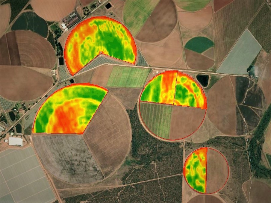
Empower your agricultural decisions with automated, cloud-based intelligence. Leverage near real-time satellite data and predictive analytics for proactive crop health monitoring.

99.9% Uptime
Global Coverage
API Ready
Satellite field analysis
Global
Coverage
Deploy anywhere on Earth
5
Crop Physiological
Indicators
5
Climatic
Indicators (Daily Update)
~Daily
PlanetScope Updates
Sentinel-2A: every 3–5 days

Connected to Your Ecosystem

GeoFarmer connects seamlessly with leading farm management platforms so your data flows where you need it.

FieldView by Bayer
Live Integration

Bayer FieldView platform

Bayer Legend
Live Integration

Bayer Legend advisory platform

John Deere
Coming Soon

John Deere Operations Center

Case IH
Coming Soon

Case IH AFS Connect Operations

How It Works

From satellite to actionable decision in three steps

Observe

Earth Observation

Harness the power of Sentinel-2A & PlanetScope satellite imagery for comprehensive field monitoring.

Process

Cloud Processing

Automated workflows extract vital field intelligence in the cloud — no hardware required.

Deliver

Deliver Intelligence

Actionable maps, statistics and alerts delivered directly to your device or platform.

Physiological Intelligence

Monitor, analyze, and predict crop performance with multi-constellation satellite precision. Our core indicators provide actionable insights for every acre.

NDVI Analysis

Normalized Difference Vegetation Index tracking for precise biomass and plant vigor assessment.

Moisture Stress

Early detection of water deficit stress before it impacts yield, optimizing irrigation strategies.

Leaf Area Index

Quantify crop canopy structure to predict photosynthetic potential and final yield outcomes.

Photosynthetic Activity

Measure active photosynthesis rates to gauge real-time plant health and growth potential.

Senescence Onset

Track the timing and rate of crop maturation to optimize harvest scheduling and yield.

Climatic Intelligence

Integrate comprehensive weather data for prescriptive analytics and robust crop modeling.

Min/Max Temp
18° / 32° C
Optimal range
Rainfall (7 Days)
45 mm
+12% vs avg
Humidity
65%
Current
Transpiration / Evap
4.2 / 5.1 mm
High stress risk

* Illustrative sample data — live values are field-specific

Advanced Platform Capabilities

Beyond core monitoring — GeoFarmer delivers a suite of intelligent tools that translate satellite data into operational outcomes.

Precision Scouting Intelligence

Algorithmically-generated scouting points derived from spatial variability analysis across your fields, ensuring agronomists target the highest-priority areas for ground-truthing.

Automated Field Reporting

Scheduled crop health reports delivered to your inbox or WhatsApp, summarising growth stage, stress indicators, and recommended actions — no manual compilation required.

Coming Soon
Anomaly Detection Alerts

Machine learning models continuously monitor crop development patterns to detect deviations from expected growth trajectories, triggering proactive alerts before issues escalate.

Productivity Zone Mapping

Classify fields into actionable management zones based on multi-season historical performance data, enabling targeted input allocation and zone-specific agronomic strategies.

Historical Trend Analysis

Compare multi-season satellite archives to track long-term field performance, yield patterns, and the measurable impact of management decisions over time.

Variable Rate Prescription Export

Export spatially-referenced field intelligence directly into variable rate application systems, closing the loop from satellite observation to precision input management.

Custom Analytics API

Consume bespoke satellite-derived analytics through a dedicated RESTful API — purpose-built for AgTech platforms requiring scientifically validated, field-specific Earth Observation outputs.

Solutions Built for Your Role

Tailored interfaces and data streams designed specifically for the unique challenges of different agricultural stakeholders.

For Farm Managers

Proactive Field Management

Stop reacting to crop stress after the damage is done. GeoFarmer provides daily satellite insights that highlight problem areas before they are visible to the naked eye, allowing for precise, targeted interventions.

  • Variable rate application maps for fertilizer and water
  • Historical yield correlation and predictive modeling
  • Automated scouting alerts sent directly to mobile
Explore Farmer Features
Avg Vigor Score
84.2
+2.4%
Stressed Area
12 Acres
-4.1%
For Risk Assessors

Regional Risk Mapping

Accurately assess regional peril and validate claims with historical and near real-time satellite data. Reduce fraudulent claims and optimize premium pricing models.

  • Historical weather event correlation overlays
  • Automated claim validation via damage extent mapping
  • Portfolio-level risk aggregation dashboards
Explore Insurer Features
Drought Risk Score
High
Flood Probability
Low
For AgTech Integrators

Seamless Data Integration

Enhance your existing platforms with our robust API. Deliver scientific-grade Earth Observation data directly into your applications, adding immense value for your end-users.

  • RESTful APIs and Webhooks for real-time sync
  • White-label widget components for rapid deployment
  • Dedicated developer support and comprehensive docs
View API Documentation
API Calls
1.2M
Healthy
Avg Latency
124ms

Built for Every Application

From smallholder support to enterprise risk management — GeoFarmer adapts to your operational context.

Crop Monitoring
Crop Growth Monitoring

Season-long physiological tracking from emergence through harvest

Irrigation Management
Irrigation & Water Management

Detect moisture stress early to optimise every litre of water

Insurance and Risk
Insurance & Risk Assessment

Validate claims and model regional risk with satellite evidence

Research and Advisory
Research & Advisory

Scientific-grade Earth Observation data for agronomists and research groups